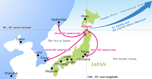
Aomori Port is the northernmost port on the main island of Honshu and is located on the interior coast of Mutsu Bay. The Port's geographic coordinates are 140:45E, 40:49N.
Because it is surrounded the Tsugaru Peninsula to the west, the Shimokita Peninsula to the northeast, and the Natsudomari Peninsula directly to the east, Aomori Port is blessed with an exceptional degree of natural tranquility. Waves average less than 0.5 meters high over 90% of the year.
Additionally, Aomori Port is directly accesible from Seoul via Aomori Airport, and the Tokyo metropolitan area can be directly accessed via the Tōhoku expressway, the bullet train, and local trains. The prefecture's border with Iwate Prefecture can be directly accessed via Aoi Mori Railway, and Hokkaido is accessible by ferry.
The climate around Aomori Port is mild, and there are clear transitions between the four seasons. Annual precipitation is around 1,400mm.
Aomori Port / CRUISE PORT GUIDE OF JAPAN


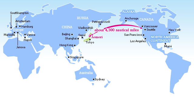
Distance between Aomori Port and Other Cities(in Nautical Miles)
| Aomori—Seattle | 4,300 n.m.. |
|---|---|
| Aomori—Petropavlovsk-Kamchatsky | 1,105 n.m |
| Aomori—Vladivostok | 547 n.m |
| Aomori—Shanghai | 1,163n.m. |
|
Aomori—Busan
|
694n.m. |
| Aomori-Yokohama | 567n.m. |
Distance and Travel Time from Tokyo to Aomori
Distance: Approximately 700 km (435 miles)
| Plane | Haneda Airport—Aomori Airport: 1 hour, 20 minutes |
|---|---|
| Rail | Tokyo Station—Shin-Aomori Station: 2 hours, 59 minutes (at earliest) |
| Expressway | Urawa Interchange—Aomori Chūo Interchange: Approximately 8 hours, 30 minutes (at 80 km/h) |

Aomori port has been in operation since the Meiji Period, beginning with but the Seikan Ferry. The port has history and prestige as a harbor town, which was the base for the large vessels that went on deep-sea fishing excursions.
The port staff, who are well-versed in various berthing facilities as well as customs, immigration, and quarantine(CIQ), supports both logistics and tourism.
Please click in the link below for more information:


